 MYCRMS


 Virtual Tour
Directions
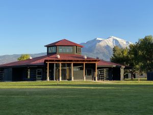
Nestled within the heart of beautiful Colorado Rocky Mountain Country, the CRMS campus (which doubles as a working ranch) sits on 300+ acres of resplendent natural beauty. Intersecting with the pastoral campus are forests, river valleys, and the magnificent 13,000 foot Mount Sopris.
Although removed from the hustle and bustle of urban life, a visit to CRMS is easily accomplished. Several airports are within driving distance and local lodging and dining amenities are aplenty.

Getting to CRMS by Air
Major airlines fly into the following airports (flight availability can vary seasonally to the regional airports):
Aspen (ASE) – approximate driving time is 30 minutes
Eagle/Vail Airport (EGE) – approximate driving time is 45 minutes
Denver International Airport (DIA) – approximate driving time is 3 hours
Grand Junction Airport (GJT)– approximate driving time is 1.5 hours
All driving times are weather dependent. For up-to-date road conditions, please visit CDOT at www.cotrip.org.
Driving to CRMS
From Denver
Take Interstate 70 west for 160 miles to the Glenwood Springs exit (#116); at the exit, stay right, then right at the traffic light (100 yards farther), then bear right over the bridge (200 yards farther). Drive south on Colo. Hwy. 82 for 11.5 miles to the Carbondale turnoff. Go one mile to the roundabout and turn right onto Main Street/County Road 106 and drive one mile to the school entrance. Look for the visitor parking and the sign for the Welcome Center. (Drive time is approximately 3 hours).
From Aspen
Head "downvalley” or west on Colo. Hwy. 82 for about 26 miles. Just past Mile Marker 12, turn left (south) on Colo. Hwy. 133. Go one mile to the roundabout and turn right onto Main Street/County Road 106 and drive one mile to the school entrance. Look for the visitor parking on the left and the sign for the Welcome Center. (Drive time is approximately 40 minutes).
